INTRODUCTION
THE ORIGIN OF THE KHMERS
Cambodia came into being, so the legend says, through the union of a princess and a foreigner. The foreigner was an Indian Brahman named Kaundinya and the princess was the daughter of a dragon king who ruled over a watery land. One day, as Kaundinya sailed by, the princess paddled out in a boat to greet him. Kaundinya shot an arrow from his magic bow into her boat, causing the fearful princess to agree to marriage. In need of a dowry, her father drank up the waters of his land and presented them to Kaundinya to rule over. The new kingdom was named Kambuja.
Like many legends, this one is historically opaque, but it does say something about the cultural forces that brought Cambodia into existence, in particular its relationship with its great subcontinental neighbour, India. Cambodia’s religious, royal and written traditions stemmed from India and began to coalesce as a cultural entity in their own right between the 1st and 5th centuries.
Very little is known about prehistoric Cambodia. Much of the southeast was a vast, shallow gulf that was progressively silted up by the mouths of the Mekong, leaving pancake-flat, mineral-rich land ideal for farming. Evidence of cave-dwellers has been found in the northwest of Cambodia. Carbon dating on ceramic pots found in the area shows that they were made around 4200 BC, but it is hard to say whether there is a direct relationship between these cave-dwelling pot makers and contemporary Khmers. Examinations of bones dating back to around 1500 BC, however, suggest that the people living in Cambodia at that time resembled the Cambodians of today. Early Chinese records report that the Cambodians were ‘ugly’ and ‘dark’ and went about naked. However, a healthy dose of scepticism is always required when reading the culturally chauvinistic reports of imperial China concerning its ‘barbarian’ neighbours.
THE EARLY CAMBODIAN KINGDOMS
Cambodian might didn’t begin and end with Angkor. There were a number of powerful kingdoms present in this area before the 9th century.
From the 1st century, the Indianisation of Cambodia occurred through trading settlements that sprang up on the coastline of what is now southern Vietnam, but was then inhabited by the Khmers. These settlements were important ports of call for boats following the trading route from the Bay of Bengal to the southern provinces of China. The largest of these nascent kingdoms was known as Funan by the Chinese, and may have existed across an area between Ba Phnom in Prey Veng Province, a site only worth visiting for the archaeologically obsessed today, and Oc-Eo in Kien Giang Province in southern Vietnam. Funan would have been a contemporary of Champasak in southern Laos (then known as Kuruksetra) and other lesser fiefdoms in the region.
Funan is a Chinese name, and it may be a transliteration of the ancient Khmer word bnam(mountain). Although very little is known about Funan, much has been made of its importance as an early Southeast Asian centre of power.
It is most likely that between the 1st and 8th centuries, Cambodia was a collection of small states, each with its own elites that often strategically intermarried and often went to war with one another. Funan was no doubt one of these states, and as a major sea port would have been pivotal in the transmission of Indian culture into the interior of Cambodia.
The little that historians do know about Funan has mostly been gleaned from Chinese sources. These report that Funan-period Cambodia (1st to 6th centuries AD) embraced the worship of the Hindu deities Shiva and Vishnu and, at the same time, Buddhism. The linga(phallic totem) appears to have been the focus of ritual and an emblem of kingly might, a feature that was to evolve further in the Angkorian cult of the god-king. The people practised primitive irrigation, which enabled successful cultivation of rice, and traded raw commodities such as spices with China and India.
From the 6th century, Cambodia’s population gradually concentrated along the Mekong and Tonlé Sap Rivers, where the majority remains today. The move may have been related to the development of wet-rice agriculture. From the 6th to 8th centuries it was likely that Cambodia was a collection of competing kingdoms, ruled by autocratic kings who legitimised their absolute rule through hierarchical caste concepts borrowed from India.
This era is generally referred to as the Chenla period. Again, like Funan, it is a Chinese term and there is little to support the idea that Chenla was a unified kingdom that held sway over all of Cambodia. Indeed, the Chinese themselves referred to ‘water Chenla’ and ‘land Chenla’. Water Chenla was located around Angkor Borei and the temple mount of Phnom Da, near the present-day provincial capital of Takeo, and land Chenla in the upper reaches of the Mekong River and east of Tonlé Sap Lake, around Sambor Prei Kuk, an essential stop on a chronological jaunt through Cambodia’s history.
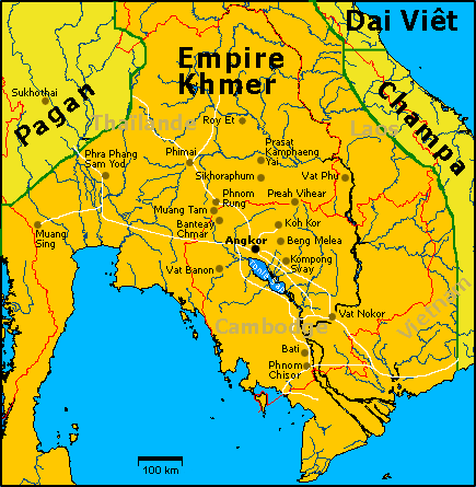
THE RISE OF THE ANGKOR EMPIRE
Gradually the Cambodian region was becoming more cohesive. Before long the fractured kingdoms of Cambodia would merge to become the greatest empire in Southeast Asia.
A popular place of pilgrimage for Khmers today, the sacred mountain of Phnom Kulen, to the northeast of Angkor, is home to an inscription that tells of Jayavarman II (r 802–50) proclaiming himself a ‘universal monarch’, or devaraja (god-king) in 802. It is believed that he may have resided in the Buddhist Shailendras’ court in Java as a young man. Upon his return to Cambodia he instigated an uprising against Javanese control over the southern lands of Cambodia. Jayavarman II then set out to bring the country under his control through alliances and conquests, the first monarch to rule most of what we call Cambodia today.
Jayavarman II was the first of a long succession of kings who presided over the rise and fall of the greatest empire mainland Southeast Asia has ever seen, one that was to bequeath the stunning legacy of Angkor. The key to the meteoric rise of Angkor was a mastery of water and an elaborate hydraulic system that allowed the ancient Khmers to tame the elements. The first records of the massive irrigation works that supported the population of Angkor date to the reign of Indravarman I (r 877–89) who built the baray(reservoir) of Indratataka. His rule also marks the flourishing of Angkorian art, with the building of temples in the Roluos area, notably Bakong.
By the turn of the 11th century the kingdom of Angkor was losing control of its territories. Suryavarman I (r 1002–49), a usurper, moved into the power vacuum and, like Jayavarman II two centuries before, reunified the kingdom through war and alliances, stretching the frontiers of the empire. A pattern was beginning to emerge, and is repeated throughout the Angkorian period: dislocation and turmoil, followed by reunification and further expansion under a powerful king. Architecturally, the most productive periods occurred after times of turmoil, indicating that newly incumbent monarchs felt the need to celebrate, even legitimise their rule with massive building projects.
By 1066 Angkor was again riven by conflict, becoming the focus of rival bids for power. It was not until the accession of Suryavarman II (r 1112–52) that the kingdom was again unified. Suryavarman II embarked on another phase of expansion, waging costly wars in Vietnam and the region of central Vietnam known as Champa. Suryavarman II is immortalised as the king who, in his devotion to the Hindu deity Vishnu, commissioned the majestic temple of Angkor Wat. For an insight into events in this epoch, see the bas-reliefs on the southwest corridor of Angkor Wat, which depict the reign of Suryavarman II.
Suryavarman II had brought Champa to heel and reduced it to vassal status, but the Chams struck back in 1177 with a naval expedition up the Mekong and into Tonlé Sap Lake. They took the city of Angkor by surprise and put King Dharanindravarman II to death. The following year a cousin of Suryavarman II rallied the Khmer troops and defeated the Chams in another naval battle. The new leader was crowned Jayavarman VII in 1181.
A devout follower of Mahayana Buddhism, Jayavarman VII (r 1181–1219) built the city of Angkor Thom and many other massive monuments. Indeed, many of the temples visited around Angkor today were constructed during Jayavarman VII’s reign. However,Jayavarman VII is a figure of many contradictions. The bas-reliefs of the Bayon depict him presiding over battles of terrible ferocity, while statues of the king depict a meditative, otherworldly aspect. His programme of temple construction and other public works was carried out in great haste, no doubt bringing enormous hardship to the labourers who provided the muscle, and thus accelerating the decline of the empire. He was partly driven by a desire to legitimise his rule, as there may have been other contenders closer to the royal bloodline, and partly by the need to introduce a new religion to a population predominantly Hindu in faith. However, in many ways he was also Cambodia’s first socialist leader, proclaiming the population equal, abolishing castes and embarking on a programme of school, hospital and road building.
DECLINE & FALL OF ANGKOR
Angkor was the epicentre of an incredible empire that held sway over much of the Mekong region, but like all empires, the sun was to eventually set.
A number of scholars have argued that decline was already on the horizon at the time Angkor Wat was built, when the Angkorian empire was at the height of its remarkable productivity. There are indications that the irrigation network was overworked and slowly starting to silt up due to the massive deforestation that had taken place in the heavily populated areas to the north and east of Angkor. Massive construction projects such as Angkor Wat and Angkor Thom no doubt put an enormous strain on the royal coffers and on thousands of slaves and common people who subsidised them in hard labour and taxes. Following the reign of Jayavarman VII, temple construction effectively ground to a halt, in large part because Jayavarman VII’s public works quarried local sandstone into oblivion and had left the population exhausted.
Another challenge for the later kings was religious conflict and internecine rivalries. The state religion changed back and forth several times during the twilight years of the empire, and kings spent more time engaged in iconoclasm, defacing the temples of their predecessors, than building monuments to their own achievements. From time to time this boiled over into civil war.
Angkor was losing control over the peripheries of its empire. At the same time, the Thais were ascendant, having migrated south from Yunnan to escape Kublai Khan and his Mongol hordes. The Thais, first from Sukothai, later Ayuthaya, grew in strength and made repeated incursions into Angkor before finally sacking the city in 1431 and making off with thousands of intellectuals, artisans and dancers from the royal court. During this period, perhaps drawn by the opportunities for sea trade with China and fearful of the increasingly bellicose Thais, the Khmer elite began to migrate to the Phnom Penh area. The capital shifted several times over the centuries but eventually settled in present day Phnom Penh.
From 1600 until the arrival of the French in 1863, Cambodia was ruled by a series of weak kings beset by dynastic rivalries. In the face of such intrigue, they sought the protection – granted, of course, at a price – of either Thailand or Vietnam. In the 17th century, the Nguyen lords of southern Vietnam came to the rescue of the Cambodian king in return for settlement rights in the Mekong Delta region. The Khmers still refer to this region as Kampuchea Krom (Lower Cambodia), even though it is well and truly populated by the Vietnamese today.
In the west, the Thais controlled the provinces of Battambang and Siem Reap from 1794 and held much influence over the Cambodian royal family. Indeed, one king was crowned in Bangkok and placed on the throne at Udong with the help of the Thai army. That Cambodia survived through the 18th century as a distinct entity is due to the preoccupations of its neighbours: while the Thais were expending their energy and resources in fighting the Burmese, the Vietnamese were wholly absorbed by internal strife. The pattern continued for more than two centuries, the carcass of Cambodia pulled back and forth between two powerful tigers.
THE KHMER ROUGE REVOLUTION
Upon taking Phnom Penh, the Khmer Rouge implemented one of the most radical and brutal restructurings of a society ever attempted; its goal was a pure revolution, untainted by those that had gone before, to transform Cambodia into a peasant-dominated agrarian cooperative. Within days of coming to power the entire population of Phnom Penh and provincial towns, including the sick, elderly and infirm, was forced to march into the countryside and work as slaves for 12 to 15 hours a day. Disobedience of any sort often brought immediate execution. The advent of Khmer Rouge rule was proclaimed Year Zero. Currency was abolished and postal services were halted. The country cut itself off from the outside world.
In the eyes of Pol Pot, the Khmer Rouge was not a unified movement, but a series of factions that needed to be cleansed. This process had already begun with attacks on Vietnamese-trained Khmer Rouge and Sihanouk’s supporters, but Pol Pot’s initial fury upon seizing power was directed against the former regime. All of the senior government and military figures who had been associated with Lon Nol were executed within days of the takeover. Then the centre shifted its attention to the outer regions, which had been separated into geographic zones. The loyalist Southwestern Zone forces under the control of one-legged general Ta Mok were sent into region after region to purify the population, and thousands perished.
The cleansing reached grotesque heights in the final and bloodiest purge against the powerful and independent Eastern Zone. Generally considered more moderate than other Khmer Rouge factions, the Eastern Zone was ideologically, as well as geographically, closer to Vietnam. The Pol Pot faction consolidated the rest of the country before moving against the east from 1977 onwards. Hundreds of leaders were executed before open rebellion broke out, sparking a civil war in the east. Many Eastern Zone leaders fled toVietnam, forming the nucleus of the government installed by the Vietnamese in January 1979. The people were defenceless and distrusted – ‘Cambodian bodies with Vietnamese minds’ or ‘duck’s arses with chicken’s heads’ – and were deported to the northwest with new, blue kramas (scarves). Had it not been for the Vietnamese invasion, all would have perished, as the blue krama was a secret party sign indicating an eastern enemy of the revolution.
It is still not known exactly how many Cambodians died at the hands of the Khmer Rouge during the three years, eight months and 20 days of their rule. The Vietnamese claimed three million deaths, while foreign experts long considered the number closer to one million. Yale University researchers undertaking ongoing investigations estimated that the figure was close to two million.
Hundreds of thousands of people were executed by the Khmer Rouge leadership, while hundreds of thousands more died of famine and disease. Meals consisted of little more than watery rice porridge twice a day, meant to sustain men, women and children through a back-breaking day in the fields. Disease stalked the work camps, malaria and dysentery striking down whole families; death was a relief for many from the horrors of life. Some zones were better than others, some leaders fairer than others, but life for the majority was one of unending misery and suffering in this ‘prison without walls’.
As the centre eliminated more and more moderates, Angkar (the organisation) became the only family people needed and those who did not agree were sought out and destroyed. The Khmer Rouge detached the Cambodian people from all they held dear: their families, their food, their fields and their faith. Even the peasants who had supported the revolution could no longer blindly follow such madness. Nobody cared for the Khmer Rouge by 1978, but nobody had an ounce of strength to do anything about it…except the Vietnames.
The temple history below :
Angkor Site and Angkor Wat temple
Angkor is one of the few archeological sites that can actually be seen from outer space. It is the largest historic site of over 400 sites that are listed in the UNESCO World heritage list (UNESCO: United Nations Educational, Scientific and Cultural Organization). Angkor means “city or capital”; it was a glorious period of the Khmer empire for 6 century from 802 to 1431.
Angkor Thom city
Angkor Thom is 1.7 km north of Angkor Wat. It was built by King Jayavarman VII (1181-1220) for dedicating to Mahayana Buddhism. Angkor Thom means ‘Great City’, the last capital of Angkor. It served as the religious and administrative centre of Khmer Empire. The capital was bigger than city in Europe at the time. The population in the city may have been as high as one million.
Pre Rup Temple
It takes around 30 minutes to 1 hour to visit it. Pre Rup was built in the middle of the 10th century by king Rajendravarman II (944 – 968). He moved his capital from Koh Ker, 70 km from Angkor, to Angkor. Pre Rup was his state temple of his city that means he built this temple in the center of the capital.
Bayon Temple
Bayon located in the centre of ‘The Great City’, was a golden tower. A Chinese official, Zhou Daguan, who was sent by Timur Khan, grandson and successor of Kublai Khan, to the court of Shrindravarman III, the Khmer Sovereign who ruled from 1295 to 1307. Zhou Daguan came to Cambodia in 1296 and return in 1297. He wrote the book upon his return to China about everyday life of ancient Cambodia (Freeman 2006). He revealed about the great city and Bayon temple that: The wall forms a perfect square, with a stone tower at each face. At the (magical) center of the Kingdom (i.e. the central point of the city) rises a Golden Tower (Bayon) flanked by more than twenty lesser towers and several hundred stone chambers.
Banteay Srei Temple
It is located far from Angkor site and about 32 kilometers to the North of Siem Reap town near Phnom Kulen. It takes around 1 hour to reach it and 30 minutes at least to finish your visit. Banteay Srei, ‘Citadel of women’ was built by a Brahman priest or Guru ‘Yajnavaraha’ during the reign of King Rajendravarman II (944-967) and Jayavarman V (968-1001) in a small city call ‘Isvarapura’.
Ta Prohm Temple
Ta Prohm located at the east of Angkor Thom. It was built in the middle of 12th century to early 13th century by king Jayavarman VII (1181-1220) for Buddhist. The temple was invaded by Jungle and remains intact. Kapok tree’s root spread over, under and in between the stones, probing walls and terraces apart, as their branches and leaves intertwine to form a roof above the structures.
Beng Mealea Temple
Beng Mealea, an Angkorian temple located approximately 80 km from Cambodia’s Siem Reap, is the place to visit if you want to feel like an explorer. Here, the jungle and the ruins are one. The encroaching plants make Ta Prohm look like a well-manicured garden. Because of the temple’s distance from Siem Reap, it sees considerably less tourist traffic than the other temples in the region. For the kind of peace available in this huge, overgrown temple, the long ride is well worth the trip.
Preah Khan Temple
Preah Khan is a modern name means ‘sacred sword’ of Khmer kingdom, a copy of which is kept in the Royal Palace in Phnom Penh. The original name is Nagarajayashri means ‘the fortunate city of victory’. It was built by king Jayavarman VII between 1184 and 1191 for dedicating to his father ‘Dharanindravarman’, identified with the bodhisattva Lokeshvara. Pheah Khan was a university of Buddhist during that time (Freeman 2006).
Neak Pean Temple
A small island temple located in the middle of the last baray (the Preah Khan Baray or Jayatataka) to be constructed by a Khmer king in the Angkor area. The central temple sits at the axis of a cross or lotus pattern of eight pools. Originally known as Rajasri, Neak Pean took its modern appellation, which means ‘coiled serpents,’ from the encoiled nagas that encircled the temple. The temple is faced by a statue of the horse, Balaha, saving drowning sailors. Though originally dedicated to Buddha, Neak Pean contains several Hindu images. Neak Pean may have served an absolution function, and the waters were thought to have healing properties. During the dry season when the water is low, check out the animal and human headwater spouts at the outside center of each pool. Neak Pean is most photogenic in the wet season when the pools are full.
Kbal Spean
‘Kbal Spean’ is a natural bridge which has given its name to the river it crosses and to the sacred site established along the river for more than a millenium. The majority of Kbal Spean’s archaeological vestiges date to the 11th to 13th centuries. From just above the natural bridge to the north, down to the waterfall below, the Kbal Spean river bed is covered with sculptures of lingas, the symbol of the God Shiva’s supreme essence. Some of the lingas are on pedestals in the form of their female counterpart, the yoni. The river banks, along with basins carved deep into the river bed, are likewise sculpted with a variety of scenes, symbols and inscriptions. The most recurrent theme depicted is the recreation of the world fallen into chaos. The God Vishnu reclines on the ocean in meditation, absorbing the watery chaos below; from his navel there grows a lotus flower bearing the Recreator, Brahma. Flowing past and over these reliefs, the water is sanctified before branching off to form the Siem Reap and Puok rivers which continue south onto the plain and through the temple complexes of Angkor to the Tonle Sap lake.
Floating Village
Chong Khneas is the floating village at the edge of the lake closest and most accessible to Siem Reap. If you want a relatively quick and easy look at the Tonle Sap, boat tours of Chong Khneas are available, departing from the Chong Khneas boat docks all day long. Take a Car the 11-15km from Siem Reap to the boat docks where there are always boats waiting for passengers. A two-hour boat trip through the floating village runs $15 each person. The boatman will probably point out the differing Khmer and Vietnamese floating households and the floating markets, clinics, schools and other boatloads of tourists. Chong Khneas, while interesting, is over-touristed and is not as picturesque and ‘unspoiled’ as floating villages further from Siem Reap. The boat trip usually includes two stops: one at a touristy floating ‘fish and bird exhibition’ with a souvenir and snack shop, and the other at the very highly recommended Gecko Environment Centre, which offers displays and information introducing the ecology and biodiversity of the lake area.